Buying a waterfront lot on Lake Keowee should feel exciting, not uncertain. You want the right views, a dock that actually gets approved, and a build site that does not surprise you with rock blasting or septic issues. In this guide, you will learn how to evaluate a Lake Keowee lot in 29682 step by step, including shoreline rules, on‑site checks, permitting, and common cost drivers. Let’s dive in.
Start with shoreline rules
Before you look at views or trees, confirm what the shoreline allows. Lake Keowee is part of Duke Energy’s Keowee‑Toxaway Hydroelectric Project, and Duke manages docks and shoreline work through a Shoreline Management Plan, often called the SMP. You can review the SMP and permit path through Duke Energy Lake Services.
- Full‑pond elevation is commonly reported at about 800 feet above mean sea level. The SMP references this elevation and the Project Boundary when measuring permitted work. See Appendix E5 for context on elevations and jurisdiction in the Keowee SMP documents.
- Shoreline classification matters. Some zones allow docks and riprap with conditions. Others restrict or prohibit them. Always verify the classification for the specific lot on the SMP map.
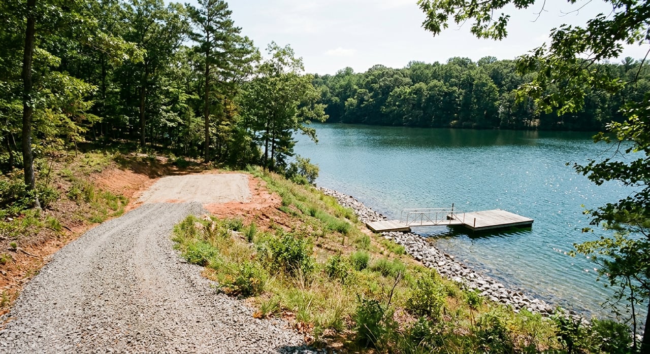
- Common Keowee dock rules you will see in practice include one dock per deeded lot, typical dock setbacks off projected lot lines, spacing from neighboring docks, a commonly enforced 1,000 square foot maximum dock footprint, and limits on how far a dock can extend into a cove, often no more than 120 feet or one‑third of the cove width. Treat these as typical guidelines and confirm exact limits with Lake Services for your lot.
- Permit timing and fees are part of planning. Applications usually require a plat, drawings, GPS points, and photos. Many lake permits are valid for 12 months. Budget for application fees and a Habitat Enhancement Program fee where applicable. Confirm current requirements directly with Lake Services.
Why this matters: the ability to place a dock in your preferred location, with the size you want, can change a lot’s value. Get clarity on shoreline rules before you fall in love with a view.
Check buildability on land
A waterfront lot can look perfect at the waterline and be costly where you intend to build. Spend time on the upland portion of the property.
Orientation, views, and sun
Stand where you plan to build and look across the water. West‑facing coves tend to deliver sunsets and more late afternoon heat. South exposures get more daylight through the year. North‑facing sites feel cooler and hold shade longer. If sunrise or sunset is important to you, visit at that time of day.
Slope, driveway, and access
Slope drives budget. Steep grades raise costs for grading, retaining walls, erosion control, and long or switchback driveways. Consider where heavy equipment will stage and whether a temporary construction entrance is practical. If access involves a private road or shared driveway, confirm maintenance responsibilities and whether any upgrades are required by local standards. Pickens County issues building and permit approvals for on‑lot work. Use county building code resources to understand local processes through the Pickens County Building Codes/Permits materials.
Soils, bedrock, and geotechnical
The Upstate sits near the Blue Ridge and Piedmont transition, where metamorphic bedrock and variable saprolite soils are common. Depth to rock can change over short distances, and some sites need rock excavation, anchors, or specialized foundations. A geotechnical investigation before you commit to a build plan can clarify foundation type and excavation limits. The South Carolina Department of Natural Resources offers regional geologic context in the Jocassee Gorges planning resources.
Flood risk and elevations
Lake Keowee is a managed pool. The lake’s full pool elevation and Duke’s Project Boundary are different from FEMA’s mapped flood zones. Check both for your proposed building envelope.
- Verify the property’s elevation relative to the 800‑foot full‑pond level and the Project Boundary in the SMP documents.
- Review FEMA Flood Insurance Rate Maps using the FEMA Flood Map Service Center. If your build footprint sits in a Special Flood Hazard Area, plan for elevation and insurance impacts.
Septic and water
Many Lake Keowee lots in Six Mile are not served by public sewer. Expect an on‑site septic system unless a community system is available. Ask the seller and the county for the septic permit file and any perc or soil evaluation records. If no records exist, you will need site testing and a septic design approved by the local permitting authority. The U.S. Environmental Protection Agency explains how local agencies manage onsite systems in its septic systems guidance.
For water service, verify whether the lot is served by the Six Mile Rural Community Water District or will require a private well. Check service areas and contact details at the Six Mile Rural Community Water District.
Docks and shoreline permits: what to verify
If a dock exists, ask for the permit ID and whether it is transferable. If there is no dock, confirm that the shoreline classification allows one and how large and far it can extend.
- Dock size and distance rules are commonly enforced at Lake Keowee. A 1,000 square foot maximum footprint, setbacks off lot lines, minimum spacing between docks, and extension limits based on cove width are typical. Treat these as general rules of thumb until Lake Services confirms specifics for your lot.
- Applications usually require a current plat with shoreline measurements, a surveyor’s seal, drawings, GPS coordinates, and site photos. Many permits are issued for 12 months. Expired permits often require a full reapplication.
- Shoreline stabilization, like riprap, is regulated and may involve coordination with state wildlife and environmental reviewers. Some zones restrict or prohibit dredging.
Tip: A local dock contractor who works Lake Keowee regularly can pre‑screen the SMP maps and help you assemble a strong application through Duke Energy Lake Services. Build your purchase timeline with permit review time in mind.
Budget drivers and common pitfalls
Waterfront development budgets are shaped by the ground you cannot see at first glance.
- Rock and slope can add costs for excavation, retaining walls, and long driveways. A geotechnical report often changes foundation strategy and budget.
- Septic systems may require engineered solutions if soils are marginal or space is tight.
- Dock projects vary widely in cost depending on size, materials, lifts, and site access. National estimates can help you set a preliminary budget, but you will want site‑specific bids. For general price context, see typical ranges summarized by dock builders and contractors.
- Permit timing matters. Lake and shoreline permits can involve multiple reviews and take weeks to months. Plan your construction calendar around permit validity windows.
- Do not assume that an existing dock is transferable or that a structure is grandfathered. Get Duke Lake Services to confirm in writing.
Local contacts to check early
- Duke Energy Lake Services and the Keowee SMP page are your sources for shoreline classifications, permit applications, and dock rules. Start here: Keowee‑Toxaway Shoreline Management Plan.
- Pickens County Building Codes and Permitting handle building, driveway, and septic permits. Review local procedures and inspection requirements in county resources: Pickens County Building Codes/Permits.
- Six Mile Rural Community Water District can confirm water service availability: service area and contact.
- Fort Hill Natural Gas Authority serves portions of Pickens County. Confirm availability for your parcel: Fort Hill Natural Gas Authority.
- If you need off‑site boat storage or a back‑up plan while permitting a private dock, review options like Sunset Marina and area public ramps.
What to request before you write an offer
Ask the seller or listing agent for these items and make your offer contingent on acceptable results when needed.
- Recorded deed, recent plat, and any shoreline easements or riparian reservations.
- Any HOA covenants or community rules that affect docks, rentals, or shoreline work.
- Copy of any existing dock permit and the dock tag number. Ask about prior transfers or expirations.
- Septic records, perc tests, and any well records. If nothing is on file, condition the contract on county‑approved septic feasibility and a perc test.
- Any prior survey, topographic map, or geotechnical report.
Who to hire and when
Line up the right professionals in this order for a smoother process.
- Licensed land surveyor for a boundary survey and basic topographic data. If you need title certainty or lender comfort, consider an ALTA/NSPS survey. Learn why this matters in this overview of an ALTA survey.
- Septic designer or onsite wastewater professional to run perc testing and design a system if needed. Follow Pickens County’s permit path and inspection steps. See the EPA’s onsite systems guidance for background.
- Geotechnical engineer to perform borings and provide foundation and retaining wall recommendations on sloped or rocky sites.
- Local builder or site contractor to price access, driveway, and site prep. Ask about temporary access for dock contractors.
- Licensed dock contractor with Lake Keowee experience to pre‑screen SMP rules for your shoreline and help assemble the Lake Services application.
On‑site field checklist
Bring a notepad, roll tape, and a basic clinometer app if you have one.
- Walk from the road to the proposed house site and to the shore. Note steep sections and possible driveway paths.
- Photograph the shoreline from multiple angles and at lake level if you can. Note substrate like rock, cobble, sand, or silt.
- Observe neighboring docks and the cove’s width for spacing and extension limits.
- Locate approximate property corners and look for visible encroachments.
- Note tree cover and any large trees near the likely building envelope.
Smart next steps for a 29682 buyer
- Pull the recorded deed and plat and confirm the Tax Map Number. Ask for any HOA or community restrictions.
- Request existing dock permit information and any septic or perc records.
- Order a boundary and topographic survey and make your purchase contingent on acceptable survey, septic, and geotechnical outcomes.
- Ask a dock contractor to review SMP maps for your shoreline classification and likely dock placement. Schedule a geotechnical borings program if the lot is sloped or rocky.
- Contact Duke Energy Lake Services and the Pickens County permit office early to confirm application checklists, current fees, and review timelines.
Buying a Lake Keowee lot in Six Mile can be straightforward when you follow a clear process and verify shoreline, soils, and services up front. If you would like a local partner to coordinate surveys, inspections, and virtual site walks, reach out to Amy Twitty for Lake Keowee lot expertise and full‑service buyer representation.
FAQs
What controls dock approvals on Lake Keowee in 29682?
- Duke Energy manages docks and shoreline work through the Keowee‑Toxaway Shoreline Management Plan. Start with the SMP and Lake Services to confirm your shoreline classification and permit path.
How do I check flood risk for a Lake Keowee homesite?
- Verify the property’s elevation relative to Keowee’s 800‑foot full‑pond level in SMP materials and review FEMA maps for your building footprint at the FEMA Flood Map Service Center.
Do most Six Mile waterfront lots have public sewer?
- Many lots rely on on‑site septic systems. Ask for county septic records and plan for a perc test and approved septic design if no permit exists. See the EPA’s onsite systems overview.
Can I rely on an existing Lake Keowee dock to transfer with the sale?
- Not automatically. Dock permits can require a transfer application and fee, and expired permits may need a full reapplication. Confirm status and transferability with Duke Lake Services.
Who provides water and natural gas around 29682?
- Check water availability with the Six Mile Rural Community Water District and confirm natural gas service with the Fort Hill Natural Gas Authority. Not all parcels have access.
What survey should I order for a waterfront lot purchase?
- At minimum, get a current boundary and topographic survey. For title‑level detail on easements and encroachments, many buyers choose an ALTA/NSPS survey. Learn more here: What is an ALTA survey.
